


Eklutna Precinct, Anchorage Municipality, Alaska
About
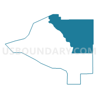
Outline

Summary
| Unique Area Identifier | 523196 |
| Name | Eklutna Precinct |
| County | Anchorage Municipality |
| State | Alaska |
| Area (square miles) | 577.56 |
| Land Area (square miles) | 555.19 |
| Water Area (square miles) | 22.36 |
| % of Land Area | 96.13 |
| % of Water Area | 3.87 |
| Latitude of the Internal Point | 61.27958360 |
| Longtitude of the Internal Point | -148.87537890 |
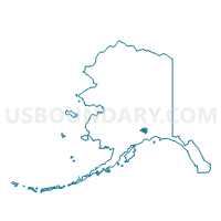
Maps

Graphs
Select a template below for downloading or customizing gragh for Eklutna Precinct, Anchorage Municipality, Alaska


Neighbors
Neighoring Voting District (by Name) Neighboring Voting District on the Map
- Butte Precinct, Matanuska-Susitna Borough, AK
- Chugach Park No. 1 Precinct, Anchorage Municipality, AK
- Fairview Precinct, Matanuska-Susitna Borough, AK
- Girdwood Precinct, Anchorage Municipality, AK
- Peters Creek No. 1 Precinct, Anchorage Municipality, AK
- Peters Creek No. 2 Precinct, Anchorage Municipality, AK
- Sheep Mountain Precinct, Matanuska-Susitna Borough, AK
- Valdez No. 3 Precinct, Valdez-Cordova Census Area, AK
Top 10 Neighboring County Subdivision (by Population) Neighboring County Subdivision on the Map
- Anchorage census subarea, Anchorage Municipality, AK (291,826)
- Matanuska-Susitna census subarea, Matanuska-Susitna Borough, AK (88,995)
- Chugach census subarea, Valdez-Cordova Census Area, AK (6,684)
Top 10 Neighboring Place (by Population) Neighboring Place on the Map
Top 10 Neighboring Unified School District (by Population) Neighboring Unified School District on the Map
- Anchorage School District, AK (291,826)
- Matanuska-Susitna Borough School District, AK (88,995)
- Chugach School District, AK (469)
Top 10 Neighboring State Legislative District Lower Chamber (by Population) Neighboring State Legislative District Lower Chamber on the Map
- State House District 16, Chugiak-South Mat-Su, AK (21,559)
- State House District 32, Chugach State Park, AK (19,952)
- State House District 12, Richardson-Glenn Highways, AK (14,811)
Top 10 Neighboring State Legislative District Upper Chamber (by Population) Neighboring State Legislative District Upper Chamber on the Map
- State Senate District H, AK (47,533)
- State Senate District P, AK (37,696)
- State Senate District F, AK (36,503)
Top 10 Neighboring 111th Congressional District (by Population) Neighboring 111th Congressional District on the Map
Top 10 Neighboring Census Tract (by Population) Neighboring Census Tract on the Map
- Census Tract 1.01, Anchorage Municipality, AK (5,736)
- Census Tract 13, Matanuska-Susitna Borough, AK (5,461)
- Census Tract 1.02, Anchorage Municipality, AK (5,259)
- Census Tract 6.01, Matanuska-Susitna Borough, AK (4,481)
- Census Tract 3, Valdez-Cordova Census Area, AK (4,420)
- Census Tract 2.04, Anchorage Municipality, AK (3,381)
- Census Tract 29, Anchorage Municipality, AK (2,570)
- Census Tract 2, Matanuska-Susitna Borough, AK (2,050)
Top 10 Neighboring 5-Digit ZIP Code Tabulation Area (by Population) Neighboring 5-Digit ZIP Code Tabulation Area on the Map
- 99577, AK (25,771)
- 99645, AK (25,176)
- 99567, AK (9,211)
- 99686, AK (4,005)
- 99587, AK (2,250)
- 99674, AK (1,444)